3D Laser scanner for point cloud surveying

The 3D laser scanner is the best tool to improve the quality and speed in the processes of digitalization of assets, whether industries, buildings or infrastructure.
Today, the laser scanner is the most appropriate technology for the task of producing, at a commercially viable cost, a precise basis for modeling the built environment, being the primary tool in the process of obtaining the point cloud.
Fundamentally, a laser scanner is a massive data capture system capable of recording millions of points in a few minutes. The system obtains the information with a distance meter which is deviated through a lens and a photographic camera that captured the color of the raised points. At the same time the scanning system is capable of analyzing the vertical and horizontal output angle of the laser with great precision. The sum of these elements results in a cloud of thousands of points, each of which is known for its relative distance to the recording element, its position in x, y, z, the value of its reflectance and its RGB value.
This time we have incorporated the Leica RTC360 scanner with Cyclone Register 360 processing software, one of the most modern and versatile on the market today. It is capable of capturing 2 million points per second, with a range of 130 meters and a 3D accuracy of 1.9 mm to 10m, has a Visual Inertial System (VIS) that allows real-time recording and front cameras that allow the capture of images in HDR.


ADVANTAGES OVER CONVENTIONAL SYSTEMS
An improvement over the technology previously used is the speed of recording and representation of the environment in a digital format. Once the survey and processing of the data have been carried out, we obtain a 3D representation of the area with metric solidity, where everything that is represented is true to reality, leaving no room for inventions or suppositions anywhere in the registration area.
One more element to take into account of this technology is the possibility of making multiple queries during the development of the project. The classic methods of direct measurement allow only one consultation of the dimensions taken in the field and we can not make more measurements without going to the field again. The laser scanner opens a new window to these cases since it not only allows to take measurements, but we can make a visual inspection of the space, thus speeding up all subsequent work.
The laser technology also allows to perform mobile mapping, technology consisting in placing the scanner on a mobile platform (a car, drone, backpack …) and raise an area moving the scanner in the environment to study. This methodology is used to lift roads, large expanses of land or quarries among others, but requires the use of more equipment matched to the scanner proving more expensive.
A 3D laser scanner offers the following advantages over other measurement techniques:
- Fast data acquisition saves money and saves time.
- Millimetric accuracy in the measurements.
- Quality and level of detail that provides information with a unique level.
- Efficiency by avoiding additional measurements or verification.
- Versatility as it can be adapted to all types of terrain and greater range in working hours, as it is not affected by luminosity.
- Compatibility with photogrammetric systems (digital cameras, drones) when the specific circumstances of the project require it (large extensions, limited access…).
POINT CLOUDS AND BIM ENVIRONMENT
Currently, the laser scanner is one of the best systems for mass data acquisition capable of accurately reproducing reality and is the most effective for its speed and high accuracy, becoming one of the best tools for creating clouds of points suitable for subsequent implementation in a BIM environment.
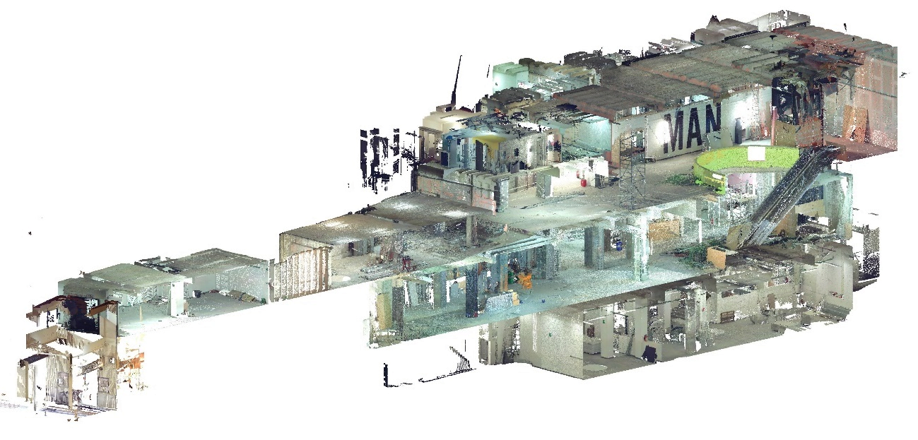
A 3D point cloud is the first product resulting from laser scanning or digital photogrammetry. It is made up of millions of points positioned three-dimensionally in space, forming a physical entity with millimetric accuracy and representing its external surface. The 3D point cloud contains extensive metric information about the scanned surfaces, as well as information about their colour and reflectivity of the material. The main objective of obtaining a 3D point cloud is to facilitate work in our different sectors, as well as to obtain fast products, reduce costs, reduce project preparation times and obtain better quality results, with a high level of detail.
Once the Point Cloud is obtained, and after a process carried out using specific software, the information is adjusted, processed and imported into a BIM platform to begin the final 3D modeling process.
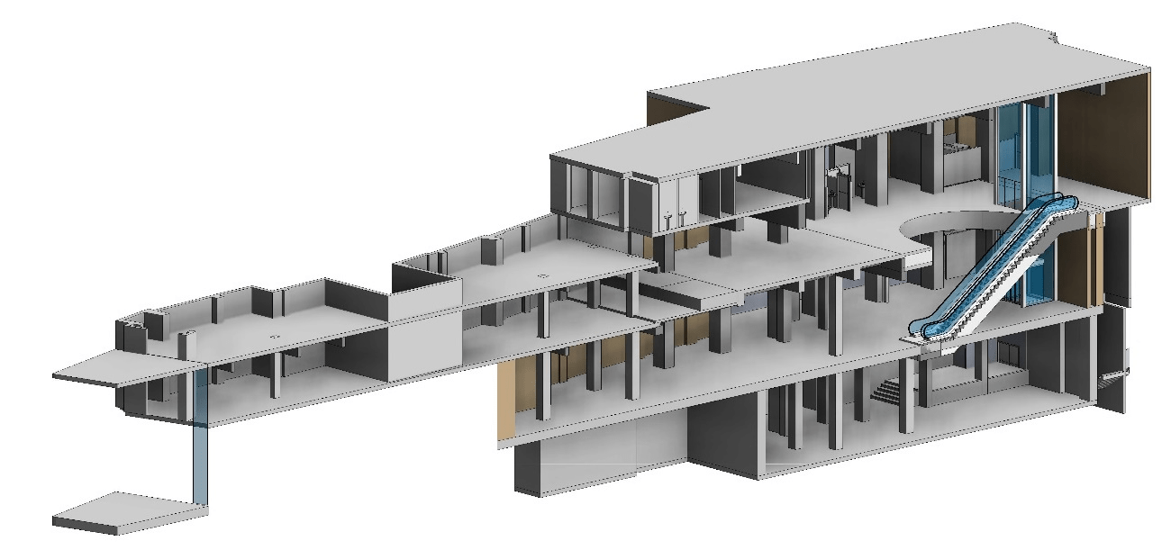
BIM MODEL FOR THE CONSTRUCTION OF THE DIGITAL TWIN
In a last phase, we can integrate the 3D BIM model with databases to build the Digital Twin of the asset that will contain, in addition to its geometric information and the data collected from the physical twin, all that parametric information necessary for its use in:
- In Design and Build phase, where we will incorporate planning and budget information.
- In Opreation and Maintenance phase, where we will incorporate inventory information for later integration with asset exploitation tools.
The BIM DIGITAL TWIN also allows us to obtain data in real time for better decision making, and complemented with technologies such as Augmented Reality and Virtual Reality, we can facilitate the assimilation and understanding of all information.

These new digital processes are changing the way of working, providing multiple benefits: they allow faster and more efficient results that impact on significant savings in costs and execution time, and improve the quality of processes reducing possible errors, being essential to adopt them to optimize business productivity and not lose competitiveness.