Methodology for urban services’ feasibility analysis through GEOBIM technology


Historically, public services that have been most successful in their operation have been those that in their planning have better adapted to citizens, urban environment, culture and demographic inertia. A clear example of this are the water and electricity basic services, which arrive proportionally to the areas of consumption and their rates are generally proportional to the cost (excluding fees, taxes, etc.).
In the framework of Urban Solid Waste Integral Management, it should not be different but the reality is that the costs far exceed the income generated by the system and, on the other hand, citizens have not perceived the culture of saving, whereas they do have it when taking into account water or electricity, incorporating in their daily habits of water and electricity consumption minimization, knowing that there are direct savings in their family expenses.
In the area of Urban Solid Waste Integral Management (USW), the most effective way to achieve an equivalent culture to the ones of water or electricity is an individualized service where waste collection is carried out “door-to-door”. Its efficiency lies in the following aspects:
- The citizen perceives a greater closeness in the service and assumes co-responsibility with the system more closely.
- It allows a greater implementation immediacy as it does not require large mobilizations or investments in infrastructure.
- The system takes a path aligned with the principle of “polluter pays” therefore in reverse, citizens through their work of segregation help reduce the costs of the comprehensive management system and therefore, in the future could even perceive Bonuses that reduce the rate imposed.
- Countries that practice segregated house-to-house collection reach 45-50% levels of packaging and packaging recovery, while countries that opt for the containerization or non-segregation system reach quotas, at best, of up to 40%.
Recently, the ‘Zero Waste Europe’ network’s coordinator, Johan Marc Simon, has pointed out that the door-to-door collection system is very effective and should be carried out in all European cities. “This system works very well because the collected materials are characterized by a greater purity and therefore greater value in the market of the treatment or the commercialization”.
Within Europe, in Flanders (Belgium), most of the municipalities in this area use this selective collection system, which makes it possible to make use of 75% of waste. In countries where about 70-90% of the waste goes to final disposal (landfills or controlled deposits), the amount of product recovered for recycling decreases radically up to 5-10% recovery rates.
In this public service of waste selective collection, it is of special relevance the preparation prior to the planning where a very precise characterization is required regarding the production of this waste, their quantity and quality (purity) as well as in detailed analysis of the housing profile (Houses, buildings, condominiums, etc.)
All this has been developed historically through GIS tools reaching an asymptotic line of evolution where GeoBIM technology manages to enhance the multi-criteria analysis of the cities allowing:
- To integrate statistical, socio-economic, urban and other data.
- To analyse and cross the information collected regarding the experiences of door-to-door segregated collection with population information obtained from the population characterization of urban, commercial, industrial, similar-to-rural sectors, and others.
- To implement selection criteria for the territories, considering at least the Socioeconomic Degree level of the population, population density, urban solid waste generation, existence of clean points in the collection and classification area/centre or other valorisation facility, capacity of Municipal management in the territory, sustainability possibilities of this type of segregated collection in the territory, connectivity, among others.
- To analyse and evaluate the behaviour’s particular situation in front of segregated collection and segregation of household waste according to per-capita income and family expenses, household profile, behaviour patterns of the sector (residential, commercial , Hotel, industrial, etc.).
- To analyse municipal contexts that comply with previously defined variables.
- To systematize the information and cross the variables so that they generate a prioritized listing for different scenarios and preparation for test phases as regional pilots.
- To introduce adjustment parameters to the model through manual entries of the results obtained from random samplings of the composition of urban solid waste.


Generally, this type of planning projects start with pilot tests in representative areas that allow shaping results prior to the integral implementation. These projects usually include the following activities:
- Creation of a comparative framework of social, technical, economic and environmental aspects, as well as comparison of weaknesses, threats (critical nodes), opportunities and strengths of selected experiences. The same scenarios worked in the RMS are to be introduced in the comparative parameters, therefore the comparison will take into account 3 existing models in urban areas and 3 existing models in rural areas.
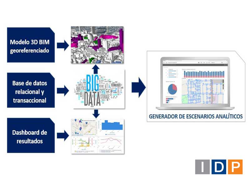
- Creation of the GEOBIM 3D dimensional geographic model of the Metropolitan Region of Santiago de Chile with its 52 communes, modelling the physical urban planning information of roads, buildings, green spaces, public transport waiting points, taxi stops, as well as environmental information on the location of collection centres, sanitary landfills, collaborating companies, involved entities, main actors, etc.
- Identification of the architectural units in geo-reference and road, as well as their condition of location in the urban or rural level referenced commune, profile of house, room units, etc.
- Design and creation of a SQL-BigData database where the obtained, analysed, selected and filtered information of the BASE, REFERENCES AND FIELD information is compiled.
- Design and creation of the statistical numeric model, as well as the insertion of adjustment parameters derived from the experience obtained in the field, meetings, characterizations, etc.
- Design and creation of the Interactive and Interoperable analysis panel, such as Qlikview dashboard, for the extrapolation and export of scenarios.
- Design and creation of scenarios analysis framework, as well as territories for the selection of pilots through the multiple sequences of territory conformation to develop the pilots.
- Preliminary proposal of pilots based on objective data through reporting focused on media tree methodology considering, for example, that pilots with the greatest number of economic, urban, technical, socio-political means are a priority.
- Creation of the website for the introduction of information surveys to determine a real-time self-assessment.


Through this technology, IDP offers its customers a feasibility analysis environment fully aligned with the current trend of public services monitoring so widespread under the slogan of Smart Cities, as well as the use of analytical technologies of large databases (Big Data) as well as the centralization of city information in models based on metadata dimensions (CIM: City Information Modelling, term derived from BIM: Building Information Modelling).
Finally, the GeoBIM platform projects the analysis results in analysis graphical platforms such as Business Intelligence, where information is updated and filtered on a permanent basis, progressively adjusting the real situation of balance of costs and income due to public services.


